|
|
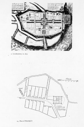
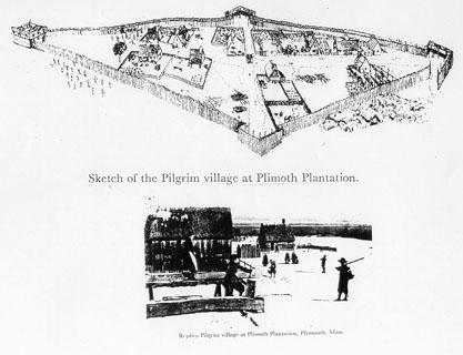
| for a place of habitation" William Bradford IntroductionIn late December of 1620, one hundred and two men, women, and children began to establish the second English permanent settlement in the New World. They christened their plantation New Plymouth after their last port of call in England. Within the next few decades, New Plymouth gave rise to numerous townships and communities in the area that came to be known as New England. The goal of its communities as well as the composition of its population placed New England in a category apart from any of the other English settlements planted in the New World during the seventeenth century. What did New Plymouth look like? And what was the character of daily existence in the town? These are questions that can only be answered by research. There are numerous surviving seventeenth century accounts that may prove to be useful in constructing a model of Plymouth plantation. However, many aspects of daily life were not deemed noteworthy by past informants and are thus lost to the historical record. The colonists may not have written about their daily activities, such as cooking dinner or constructing barns, but they did leave behind the material remains of these endeavors. The archaeological record may therefore prove valuable in learning about the day to day goings on of the colonists and how they may have perceived them. However, archaeological excavations have yet to be carried out on Plymouth plantation because it has yet to be found. The past research places the town on a Plymouth landmark known as Burial Hill, but there are many discrepancies in this interpretation. Subsequently, the plantation could just as easily lie on nearby Watson Hill. For these reasons, the previous research must be built upon and reinterpreted in order to contribute to our knowledge of the past and further our understanding of the American experience. Background: The colonization of New EnglandIn order to understand the mindset of the emigrants known today as the Pilgrims as well as their motives for colonization, we must first examine their system of beliefs. One can hardly conduct research into the history of New England without first realizing the extent and importance of its Puritan roots. Puritans, and their radical Separatist counterparts, were a minority in Old England, however they comprised the religious majority in New England. The Church of England, created by Henry VIII in the sixteenth century, made divorce feasible, rejected Latin as the official language of the Church, abolished confession, and allowed the clergy to marry (Bradford 1981: ix). Although these changes were radical for the time, many in England did not feel that they were radical enough. The Puritans wanted to reorganize and simplify the Anglican Church, thus making corruption within the Church less likely. They recognized only the sacraments of Baptism and Communion and preferred a body of church elders to the conventional Church hierarchy (Bradford 1981: x). "They wanted, above all, to return to a simpler church and to regain that passionate intensity that comes with true conversion" (Bradford 1981: xi). English Puritanism borrowed heavily from the theological teachings of Martin Luther and John Calvin, whose philosophies had spread throughout Western Europe during the sixteenth century. Luther and Calvin preached against corruption in the established churches and emphasized a more personalized covenant with God. "Puritans followed Luther and Calvin in objecting to the doctrine of Works - the submission to ecclesiastical authority and ordained participation in church ritual - because they were no substitute for the individual encounter with God" (Bradford 1981: xi). Although most Puritans wanted to reform or "purify" the Church of England, a number of groups believed that the Church was irreparable. One such group of Separatists, as they were known, had its roots in the small village of Scrooby, in Nottinghamshire, England. It was in Scrooby, in the year 1607, that a group of people came together to form an illegal separate church after withdrawing from their Anglican parishes. As English citizens were required by law to become members of the Church of England, many of the Scrooby group suffered persecution, in the form of fines and imprisonments (Simmons 1976: 16). It was for this reason that the Scrooby congregation decided to relocate to Holland, which enforced religious toleration, in 1608. William Bradford, who was a member of the group, wrote about this exodus some forty years later in New England: The homeless congregation took a year-long respite in Amsterdam, after which they settled in Leyden, "a fair and beautiful city and of a sweet situation . . ." (Bradford 1981: 16-17).Yet seeing themselves thus molested, and that there was no hope of their continuance there, by a joint consent they decided to go into the Low Countries, where they heard was freedom of religion for all men; as also how sundry from London and other parts of the land had been exiled and persecuted for the same cause, and were gone thither, and lived at Amsterdam and other places of the land. (Bradford 1981: 10) The group remained in Leyden for eleven years, "enjoying much sweet and delightful society and spiritual comfort together in the ways of God . . ." (Bradford 1981: 18). Their flock grew over the years as they accepted other exiled Englishmen into their congregation, including the notable minister John Robinson. Although they no longer suffered religious persecution at the hands of a national government, the Leyden group remained alienated. They were English men and women, removed from their homes and exiled in a strange land. They did not speak the language and were not familiar with the customs of the Dutch. "Yea, some preferred and chose the prisons in England rather than this liberty in Holland . . ." (Bradford 1981: 24). Dissention grew to the point that the congregation eventually decided to relocate. Bradford states several reasons for their removal from Holland, among which are the cultural hardships the English group bore in a strange land, as well as the increasing age of many of its members (Bradford 1981: 24). However, it seems that there were two great sources of anxiety that persuaded the congregation to migrate once again. The first was that an armistice between Spain and Holland was about to come to an end. The twelve year's truce, which began on March 30, 1609 was due to end in 1621, thus renewing the threat of religious persecution by way of the Spanish Inquisition. The second, and probably the most influential, reason for migration was the fear of acculturation into Dutch society. Many of the children of the group either had not known or could not remember much of England, and it was postulated that the children would lose their language and culture and essentially cease to be English. (Bradford 1981: 23-26) Members of the Leyden congregation ultimately made the decision to leave Holland, but they were uncertain in choosing a new place for habitation. They could not return to England for the same reasons that had forced their exile into Holland twelve years before. It appears that English America was the closest possible substitute for Old England, and they would be free to worship as they saw fit. In their struggle for a new residence, many of the group expressed a new desire "of laying some good foundation . . . for the propagation and advancing the gospel of the kingdom of Christ in those remote parts of the world . . ." (Bradford 1981: 26). This notion was significant and remained a motivation for English emigration into New England for decades to come. The congregation sent Robert Cushman and John Carver as emissaries to the Virginia Company of London, which was sponsoring the English venture at Jamestown, to apply for land patents within the Company's vast holdings. The Virginia Company accommodated the group and even granted them a patent, but it was never exploited. The Leyden assembly favored the support of a group of private backers and adventurers, headed by a London merchant named Thomas Weston. Bradford writes in his history, Of Plymouth Plantation, Thus the Leyden group acquired a set of sponsors as well as a prospective location for their plantation.[T]hey had heard, both by Mr. Weston and others, that sundry Honourable Lords had obtained a large grant from the King for the more northerly parts of that country . . . to be called by another name, viz., New England. Unto which Mr. Weston and the chief of them began to incline it was best for them to go . . . for the hope of present profit to be made by the fishing that was found in that country. (Bradford 1981: 39-40) The Leyden assembly recruited mariners and miscellaneous workers and artisans in London and set sail, aboard the Mayflower, on September 6, 1620. Of this group of one hundred and two, known today as the Pilgrims, only thirty-five were actually members of the Leyden congregation (Simmons 1976: 16). They arrived at Cape Cod on November 19, 1620 but did not find a suitable place to plant their community until the nineteenth of December. They chose a site with a protected harbor and high grounds, suitable for defense, and christened their plantation New Plymouth, after their last port of call in England. (Heath ed. 1963: 41-42) The planting of New Plymouth was followed by an influx of immigration into New England during the next three decades. During the 1630's and 1640's numerous towns sprang up in Plymouth colony while the colony of Massachusetts Bay grew to the North around the port town of Boston. Historian R.C. Simmons writes, "The arrival of the Pilgrims in Plymouth . . . marked the beginning of a voluntary movement of religiously discontented persons to America, a movement that would swell to a flood in the late 1620's and the 1630's" (Simmons 1976: 17). Other Puritan communities eagerly followed the example of the Pilgrims, who had set a precedent of leaving the Old World for the New in order to "advance the gospel . . . in those remote parts of the world . . ." (Bradford 1981: 26). The Pilgrims left England primarily to escape religious persecution by the early Stuart rulers, however, other Puritan groups came to the New World with the hope of fulfilling a greater purpose. "Their 'peculiar mission' was to establish the true Christian commonwealth that would thenceforth serve as a model for the rest of the Christian world" (Greene 1988: 21). In its religious orientation, New England differed greatly from the other English New World settlements of the time, however, religion was not the only distinguishing factor. In comparison with other English colonies, the age structure and sex ratio of the New England emigrant population closely resembled that of Old England (Anderson 1993: 102-103). The most apparent explanation for the region's demographics is that whole communities and families were often transplanted from England. "Fully 87.8 percent of the emigrants traveled with relatives of one sort or another. Nearly three-quarters came in nuclear family units, with or without children" (Anderson 1993: 104). New England also experienced lower mortality rates than either England or any of its colonies, due to relatively less serious epidemics (Greene 1988: 20). All of these factors contributed to the population growth and relative stability of New England during the seventeenth century. Problems with the Indians in the 1670's culminated in the conflict known as King Philip's War. A lack of trade and commercial farming, along with the toll of King Philip's War made Plymouth the poorest of the New England colonies. Plymouth colony had received charters from private adventurers as well as the Dominion of New England, however it had never received a formal charter from the English crown. The late 1680's were turbulent for Plymouth as it sat on the edge of bankruptcy. The story of the colony finally came to an end in 1691, when it was incorporated, by a formal charter, into the colony of Massachusetts Bay. (Simmons 1976: 108) Archaeology and the interpretation of the pastHistorical documents have long been the mainstay of researchers interested in exploring early life in Plymouth colony. The historical record of Plymouth is abundant with documents such as court records, probate inventories, deeds and wills, and eyewitness accounts. Despite the richness and diversity of the Plymouth records, they paint an incomplete picture of life in the colony. While the historical record is a valuable tool in the interpretation of the past, there is much to be learned that can not be found within the pages of a book or a court record. The simple occurrences of everyday life were things that none thought to write about and are thus lost to the historical record. Whereas informants may not have written about everyday activities, such as cooking dinner or replacing the worn clapboards of a dwelling house, they did leave behind the material remains of these endeavors. The archaeological record, with its complement of nails, shards of glass, and broken ceramics, may therefore prove helpful in learning about the everyday goings on of the colonists and how they may have perceived them. Anthropologist James Deetz writes, ". . . the combined use of archaeological and documentary materials should permit us to say something about the past that could not have been said using only one set of data" (Deetz 1996: 32). The problem that arises in conducting archaeological investigations of early Plymouth Plantation is essentially where to begin. Archaeologist Ivor Noel Hume seemingly states the obvious when he writes, "The first requirement for an archaeologist is that he have a site to dig . . ." (Noel Hume 1969: 23). However, finding a site is not always an easy task, especially if it is in an urban environment and has been continuously occupied since its settlement by European colonizers, such as New Plymouth. The remainder of this paper will therefore be spent in reviewing the past research and reinterpreting the historical sources in order to shed light on the possible whereabouts of the initial settlement and fortification of New Plymouth as well as what it may have looked like. The sourcesThere are many surviving primary sources from seventeenth century Plymouth, a great deal of which have been published. Many of the surviving accounts are essentially advertisements written by those in the colony aimed at encouraging investors and attracting prospective emigrants. Letters and personal papers also prove to be a wealth of descriptive information. And of course there are the usual state related records, such as wills, deeds, probate inventories, and court records. The following is a review of many of the primary sources that may be of interest to the researcher of early Plymouth colony. Histories and RelationsWilliam Bradford's Of Plymouth Plantation 1620-1647 is a valuable resource and a remarkable book. William Bradford, who was a member of the Leyden congregation as well as the colony's second governor, basically relates the story of the colony from its separatist roots in Leyden through the settlement and growth of Plymouth Plantation. A Relation or Journal of the English Plantation settled at Plymouth in New England . . . (1622), otherwise known as Mourt's Relation, was written by George Morton, William Bradford, Edward Winslow, and Robert Cushman to illustrate the progress of the colony and encourage English investors. This book recounts the construction of New Plymouth as well as several journeys into the surrounding areas and subsequent encounters with the Native populations. Good News from New England (1624), written by Edward Winslow and also known as Winslow's Relation, tells of the happenings of New Plymouth after the arrival of the Fortune in November of 1621. This is also a relation written with the intent of encouraging investors and highlighting the progress of the colony. A large part of this relation deals with Native and English interactions. Other sourcesA Description of New England, written by John Smith in 1616, describes the area of New England, witnessed by Smith on a voyage along the coast of New England. He speaks of the Native populations as well as New England's prospects for possible adventurers. Advertisements For the unexperienced Planters of New England, or anywhere . . . (1631), by John Smith is basically a description of the New England area. John Smith visited Plymouth and provided counts for people, houses, and livestock, as well as descriptions of the town of New Plymouth. This little account also contains John Smith's map of New England, drawn in 1614. New England's Trials (1620), also by John Smith, tells of the prosperous fishing industry of northern New England and Newfoundland and of the shipping traffic between Europe and New England. Smith wrote this book to encourage English investors and establish markets for New English fish in European countries. Three Visitors to Early Plymouth is an important compilation of letters about the settlement of New Plymouth before 1627. These letters are a wealth of descriptive information, including the only known reference to the orientation of Plymouth with compass bearings. The accounts were written by a Virginian, an Englishman, and a Dutch ambassador from the neighboring settlement of New Amsterdam. Records of the Colony of New Plymouth in New England, first published in the mid nineteenth century, is the major body of published records from Plymouth. This compilation includes items such as court records, deeds, and wills, and is invaluable to anyone doing research on Plymouth colony. MapsThere are but three known seventeenth century maps of Plymouth colony (Appendix A): Samuel de Champlain's map, drawn in 1605 and published in 1613, of Port St. Louis is most likely a map of Plymouth Harbor, complete with soundings. The map illustrates a large Indian village surrounding the harbor. This map may have been known by navigators and adventurers of the time. John Smith's map of New England, published in his Advertisements for the Planters of New England (1631), was drawn in 1614 on a voyage along the New England coast. This is a general map of southern New England and is a very detailed depiction of the coastline and inland waterways. William Bradford's sketch of "The meersteads & garden plotes of which came first layd out 1620" is the only known depiction of the original town layout. Found on the first page of Volume twelve of the Records of the Colony of New Plymouth, the sketch shows seven house lots laid out along the intersection of "the streete" and the "high way." The nineteenth century: an impetus for researchFueled by a strong nationalist mentality, nineteenth century America was a country eagerly searching for an identity. To this end, Americans began to look back to their colonial roots for a sense of pride and accomplishment. Episodes from America's colonial past became infused in the literature of the time. Henry Wadsworth Longfellow's "The Courtship of Miles Standish," for example, was first published in 1888. The legend states that John Alden, a cooper who came over on the Mayflower, went to speak to Prescilla Mullins on behalf of Miles Standish. When he began to plead his case for Miles Standish, she uttered the now famous line, "Prithee, why don't you speak for yourself John?" (Addison 1911: 128). As the stories circulated and became popular, the nation began to forge its own origins based in a mythical past complete with saints and heroes, of which American society was directly descended. It was at this time that the solemn image of the Pilgrims, dressed in black from head to toe and covered with buckles, was fabricated. The story of the Pilgrims and their flight from an oppressive English monarchy in order to establish religious freedom for all became prevalent. And why wouldn't a story such as this become popular? The Pilgrims were attractive in that they seemingly embodied much of what America stood for; religious freedom, perseverance, and an unwavering sense of individuality. They refused to adhere to an unjust law and compromise their beliefs and, in so doing, they established a nation of their own. The fact of the matter is that of the one hundred and two men, women, and children who sailed to Plymouth aboard the Mayflower, only thirty-five were actually fleeing any sort of religious persecution (Simmons 1976: 16). The sixty-seven other passengers that made up the majority of the colonists were comprised of soldiers, artisans, and laborers. However, the group is collectively known as the Pilgrims, sometimes referred to as the "Pilgrim fathers." As this latter term implies, the Pilgrims were seen as the forefathers of modern American culture, thus making nineteenth century Americans their progeny. The nineteenth century preoccupation with the story of the Pilgrims inspired many historians and researchers to look through the surviving seventeenth century documents and records. Many of the documents and court records, letters, and memoirs were transcribed and published. Consequently, many of the historical interpretations available today were composed during this time period. Many of these histories were no doubt influenced by the notion of a mythical past. For example, the author of the book The Romantic Story of the Mayflower Pilgrims, published in 1911, uses language in a way to venerate the Pilgrims as the progenitors of modern America. The intent of the author is expressed in the title of his book, and as such, the Pilgrims were much romanticized in history books as well as in the literature of the time.Such is the story of the Mayflower Pilgrims, romantic, heroic idyllic, based also upon the principles which have molded and maintained a mighty free nation . . . For on this hallowed spot, with its historic environment and its striking reminders of a great and honoured past, was rocked the cradle of a nation whose civil and religious liberty it was the first rude home. (Addison 1911: 103,111) Much of the nineteenth century research was aimed at interpreting and describing the physical aspects of Plymouth Plantation, such as its appearance as well as its location and orientation. In this line of research, one of the major works of the time is William T. Davis's Ancient Landmarks of Plymouth. First published in 1883, Ancient Landmarks of Plymouth remains a valuable resource to present day researchers. Davis's interpretations and conclusions have generally become accepted as historically accurate, however it is very likely that Davis, like others of his time, was influenced by the numerous myths and stories that were circulating about Plymouth and the Pilgrims. When one reviews the past research, it becomes apparent that there are discrepancies between the historical sources and the accepted interpretation of Plymouth Plantation. However, before these discrepancies can be highlighted or any hypothesis formulated, the geography and specific conditions of the Plymouth Bay area must be first be understood. Cape Cod's distinctive shape affords protection to the inland coastline and waterways. A long spit, known today as Plymouth Beach, juts into Plymouth Bay, a smaller subsidiary of Massachusetts Bay, and creates a protected harbor. The seashore quickly gives way to higher ground and numerous landforms, most of which are small hills and plateaus. Pleistocene glacial deposits lie above sedimentary strata as a testament to the landscape forming power of glaciation. The immediate landscape of the present site of the town of Plymouth contains several distinctive landforms worthy of noting. The first is a tidal creek that bisects the town. The creek, named Town Brook, connects a large inland lake, known as the Billington Sea, to Plymouth Harbor and feeds numerous small ponds along the way. Town Brook lies between the two highest landforms of the town; Burial Hill to the north and Watson Hill to the south. According to the United States Geological Survey (USGS), Burial Hill, so named for its cemetery, rises one hundred and twenty feet above sea level. It is significant to note that the eastern face of the hill, closest to Plymouth Harbor, is a steep incline. Watson Hill, according to the USGS, rises some ninety feet above sea level at a much more gradual pitch than Burial Hill. (See Appendix C) Keeping the landforms and general geographical features of the Plymouth area in mind, we may now return to William T. Davis and his interpretation of the town of New Plymouth. Davis does not provide a detailed model of what the town may have looked like, but he does go into detail with place names and their change over time. He pays particular attention to Burial Hill and the street names and comes to the conclusion that the initial settlement of New Plymouth must have been built upon Burial Hill. However, Davis rarely cites his sources and relies heavily on oral tradition. He subsequently uses the phrase "it is well known that . . ." often to justify his statements. Some of his assumptions are therefore questionable and should be taken as such. Burial Hill is prominent in Davis's interpretation of Plymouth Plantation. It receives its name from the cemetery located on the hill's summit. Of the grave markers in the cemetery, there are but four surviving from the seventeenth century. These are the grave stones of Edward Gray, 1681; William Crow, 1684; Hannah Clark, 1687; and Thomas Clark, 1697 (Davis 1883: 133). Before its use as a cemetery, Davis cites Burial Hill as the location for the original fortification of the town, constructed in 1622. At the time of the publishing of Ancient Landmarks of Plymouth, much was not known about site formation processes as archaeology was still very much in its infancy. It is very likely that if one were inclined to look, one may find brick fragments "a little beneath the surface" almost anywhere in Plymouth.It is well known that its commanding position induced the erection of fortifications upon [Burial Hill] at an early period . . . Traces may now be seen of the fort of the Pilgrims on the top of the hill, at what was, in the earliest days, the junction of Leyden and Spring Streets, where its guns could command both. In 1643 a watch house was built near the site of the fort, and a little beneath the surface fragments of the brick used in its construction may still be found. (Davis 1883: 130, 135) Davis states that the fort was enlarged several times and "rebuilt one hundred feet square" in 1676, at the time of King Philip's War. The following year "its material was sold to William Harlow and used by him in the construction of a house still standing." He further states, "In a recent repair of the house its oak posts and beams were laid bare, and disclosed the ancient mortises made in fitting the frame of the fort. An ancient iron hinge was also found . . . which was probably one of the hinges on which the gate of the fort was hung" (Davis 1883: 135). Nowhere in the records does it actually say that the fortification was dismantled the year following King Phillip's War. The Harlow house story may be an example of the influence that local legend exerts on historical interpretation as it can be neither confirmed nor denied. Davis devotes a significant number of pages to street names and their origins as well as their change over time. He states, "Before 1633 there were five streets and two lanes laid out within the limits of the town" (Davis 1883: 156). The first two streets, laid in 1620, created an intersection at the heart of the town. Leyden Street led eastward from the fort to the harbor and Spring Street crossed Leyden Street to connect the community to Town Brook (Davis 1883: 156-157). Davis writes of the remaining streets, William T. Davis speaks of the streets in respect to the late nineteenth century, when his book was published. For example, Davis identifies the nineteenth century Leyden Street as the pathway that led from the seventeenth century fort to Plymouth Harbor. He basically uses nineteenth century landmarks to describe the seventeenth century landscape, hence the title of his work, Ancient Landmarks of Plymouth. In doing this, the validity of some of Davis's conclusions must be called into question and they will indeed be inspected in further detail later in this paper.The second of the five streets was South Street, now Market Street, and the three others, High, now Summer Street, Main and New, sometimes in old deeds called Queen Street, now North Street. The two lanes referred to are Spring Lane . . . now called Spring Street, and Woods Lane, or 'lane leading to the woods,' which is now Samoset Street. (Davis 1883: 157) Ancient Landmarks of Plymouth is not the only nineteenth century work dealing with Plymouth. There are many nineteenth century volumes of seventeenth century records, letters, and relations, of which the editors often comment in footnotes or articles. Among these works is Alexander Young's 1841 Chronicles of the Pilgrim fathers of the colony of Plymouth. On this passage from Mourt's Relation, "so many as could went to work on the hill where we purposed to build our platform for our ordnance . . . and from whence we may see far into the sea, and might be easier impaled, having two rows of houses and a fair street," Alexander Young comments, "I think something is omitted here. The house-lots were not laid out on the hill, but in front of it, on Leyden Street" (Young 1841: 170). Young goes so far as to correct a first person account, and his note illustrates a nineteenth century model of the town of New Plymouth, with a fortification on a hill and the town beside the seashore, in front of the hill. Nineteenth century maps are very useful in visualizing the nineteenth century model of the town. The map of Plymouth Village of 1846, the map of Plymouth of 1830, and a map of Plymouth from Young's 1841 work all show a village in between the hill line and the seashore. The map of Plymouth from the 1879 Plymouth County Atlas shows Burial Hill as the "Site of a watch-tower used by Pilgrims," thus naming Burial Hill as the site of the original fortification. The 1830 and 1846 maps show Watson's Hill as the site of "the first Indian treaty" and the "first interview of Massasoit with the Pilgrims" respectively. (See Appendix B) The seventeenth century accountsIn order to gain a better understanding of what the town of Plymouth may have looked like as well as its location, the surviving seventeenth century sources must be utilized. William Bradford's sketch of the town, entitled "The meersteads & garden plotes of which came first layd out 1620," is the only known map of the original town layout (See Appendix A). The sketch shows seven house lots, facing "the streete" and bisected by a "high way." The house lots are located on what Bradford terms "The south side," while "The north side" is essentially bare. Mourt's Relation states that the number of dwellings to be built was reduced to nineteen by placing single men with families and the town was to be built "having two rows of houses and a fair street" (Heath ed. 1963: 42). During the winter of 1620-1621 the Pilgrims were forced to live aboard the Mayflower and commute to the shore daily in order to build the town. Edward Winslow writes, in a letter to George Morton dated December 11, 1621 (the following winter), "we have built seven dwelling houses and four for the use of the plantation and have made preparations for diverse others" (Young 1841: 230). Although the Fortune left thirty-five new colonists upon its departure on December 13, 1621, many of the original settlers had died the previous winter. The seven original house lots were probably meant to provide shelter for the entire group until more could be built. William T. Davis states, "It is probable . . . that in the rapidly-reduced condition of the colony the seven houses laid down on the plan were all that could be built or were needed to furnish shelter from the winter's cold . . ." (Davis 1883: 53). Soon after the departure of the Fortune the residents of the newly constructed town faced a new peril. In January of 1622, the Narragansett Indians sent a message to the people of Plymouth in the form of a bundle of arrows wrapped within a snakeskin. This was interpreted by Squanto, whom the English had befriended, as a military threat and a challenge to the well being of the colonists. As an answer to the Narragansett challenge, the Governor filled the snakeskin with powder and shot and sent it back but they would not receive it and thus sent it back to the English. (Bradford 1981: 106) Fearing the threat of an Indian attack, the colonists thought it necessary to impale their town. Edward Winslow writes of this endeavor in his relation, On March 22, 1622, three hundred and forty seven members of Virginia's English population perished in a great Algonquin uprising (Morgan 1975: 99). Upon hearing this news, the Plymouth colonists decided to fortify their newly impaled town. The erection of the fort was accomplished in two months (May-June, 1622) and was built on the hill enclosed by the palisade of the town. Bradford gives a good description of the fort in his history,In the mean time, knowing our own weakness, notwithstanding our high words and lofty looks towards them; and still lying open to all casualty, having, as yet, under GOD, no other defence than our arms: we thought it most needful to impale our town . . . Taking in the top of the hill under which our town is seated: making four bulwarks or jetties without the ordinary circuit of the pale, from whence we could defend the whole town in three whereof, are gates; and the fourth, in time to be. (Bercovitch ed. 1986: 520) This summer they built a fort with good timber, both strong and comely, which was of good defense, made with a flat roof and battlements, on which their ordnance were mounted, and where they kept constant watch, especially in time of danger. It served them also for a meeting house and was fitted accordingly for that use. (Bradford 1981: 123) There are a few valuable first person accounts of the town of New Plymouth made by visitors to the town during the 1620's. The first is in a letter from John Pory to the Earl of Southampton dated January 13, 1622/23. John Pory had been a student and friend of Richard Hakluyt, the great promoter of colonialism, and was a cousin to George Yeardley, the governor of Virginia at the time. Pory stopped by New England on his way back to Old England on a mission to inspect the fishing industry, in the hopes of getting the Virginia Company a piece of the royal monopoly held by the Council for New England. He was also to assess the new settlement of Plymouth as well as its future prospects. The town had been fortified for less than a year when John Pory visited Plymouth and his letters do not bring forth much new information, however he does give an idea of the size of the town and the extent of the palisade. And their industry as well appeareth by their building, as by a substantial palisado about their [town] of 2700 foot in compass, stronger than I have seen any in Virginia, and lastly by a blockhouse which they have erected in the highest place of the town to mount their ordnance upon, from whence they may command all the harbour. (James ed. 1963: 11) Emmanuel Altham wrote several accounts of the colony and his most useful account of the town is his first. He provides a much more detailed description of the community than John Pory, in a letter to Sir Edward Altham dated September, 1623, This reference is significant because Altham provides a count of twenty or so houses, up from Edward Winslow's December, 1621 count of seven dwellings and four common houses. He also provides a more detailed description of the town's defenses.I mean the plantation at Patuxet (Plymouth's Indian name). It is well situated upon a high hill close unto the seaside . . . In this plantation is about twenty houses, four or five of which are very fair and pleasant, and the rest (as time will serve) shall be made better. And this town is in such manner that it makes a great street between the houses, and at the upper end of the town there is a strong fort, both by nature and art, with six pieces of reasonable good artillery mounted thereon; in which fort is continual watch . . . . This town is paled round about with pale of eight foot long, or thereabouts, and in the pale are three great gates. (James ed. 1963: 24) Captain John Smith visited Plymouth plantation in 1624 and placed a description of the town in his 1631 work entitled Advertisements For the unexperienced Planters of New England, or any where. Smith writes, "their Towne containes two and thirty houses, whereof seven were burnt . . ." and he observes a population of "about an hundred and fourescore persons" (Smith 1971: 18). If John Smith's house count is correct, then the colonists must have built twelve or so dwellings in one year, since the 1623 count of "about twenty houses" by Emmanuel Altham. There are a few other possibilities for the increased number of structures between the two accounts. John Smith was writing to encourage emigration and investors and may therefore have exaggerated in order to illustrate the progress of the colony. Another possibility is that Smith may have included common houses in his count or Altham may not have included burnt structures. John Smith goes on to describe the town, which he states, "was impailed about halfe a mile, within which within a high Mount, a Fort, with a Watch-tower, well built of stone, lome, and wood, their Ordnance well mounted . . ." (Smith 1971: 18). This description is similar to the others, with the notable addition of a watch tower to the fort, and is most likely accurate. Perhaps the most descriptive of the accounts of the 1620's came from Isaack de Rasieres, a visiting ambassador from the neighboring Dutch colony of New Amsterdam. In a letter to Samuel Blommaert of circa 1628, de Rasieres writes, Isaack de Rasieres's rather lengthy account is a wealth of descriptive information. He goes so far as to describe the construction materials of the structures as well as the weight of the cannon shot. This is the first reference that contains any description of the square stockade that commanded the intersection of the town, and it is reasonable to assume that this was added between 1623 and 1628. De Rasieres's description is also the only known account of the town with reference to compass bearings, which is extremely important, as will be shown later, in assessing the possible locations for the original town site.New Plymouth lies on the slope of a hill stretching east towards the sea-coast, with a broad street about a cannon shot of 800 feet long, leading down the hill; with a [street] crossing in the middle, northwards to the rivulet and southwards to the land. The houses are constructed of clapboards, with gardens also enclosed behind and at the sides with clapboards, so that their houses and courtyards are arranged in very good order, with a stockade against sudden attack; and at the ends of the streets there are three wooden gates. In the center, on the cross street, stands the Governor's house, before which is a square stockade upon which four patereros (small cannon) are mounted, so as to enfilade the streets. Upon the hill they have a large square house, with a flat roof, built of thick sawn planks stayed with oak beams, upon the top of which they have six cannon, which shoot iron balls of four and five pounds, and command the surrounding country. The lower part they use for their church, where they preach on Sundays and the usual holidays. (James ed. 1963: 76) The previous first person accounts were used to create a working model of the town of New Plymouth by the living history museum known as Plimoth Plantation. The depiction is of a diamond shaped, palisaded town with houses lined up on either side of a main street. Garden plots are located behind the houses and continue to the extent of the palisade wall. At the center of the town is the intersection with the "square stockade upon which four patereros are mounted" identified by de Rasieres. Of the four points of the diamond shaped palisade wall, three are quadrangular bastions with entrance gates and the fourth is a square blockhouse and watch tower complete with ordnance. (See Appendix C) The model is a very useful tool and helps us to visualize the previously mentioned accounts of the town. However, there are a few possible flaws in the rendering that are worthy of noting. For example, the bastions in the model are quadrangular and most likely would have been circular, as in other English frontier fortifications of the time (Kelso 1996: 34-35). The shape of the palisade walls is unknown and could have existed in many forms, therefore the depiction of a diamond shaped town is as good a guess as can be made until archaeologists can prove otherwise. The final discrepancy in the Plimoth Plantation depiction is that it is too small. If the dwelling and population counts in the previous descriptions of the town are believed to be accurate than the model must be greatly expanded in order to hold more house and garden plots. However, it must be remembered that the Plimoth Plantation rendering is a model and is not meant to be a literal depiction of the town, therefore its greatest value is as a reference material. New Plymouth was a New World English colonial settlement, however there were numerous colonial campaigns in the Old World that had establish a precedent for English colonial frontier architecture. At the onset of colonial endeavors in Virginia and New England, a campaign was already in progress to colonize Northern Ireland. The Ulster plantation was widely known and was used as a model for other English frontier settlements. As a result, the influence of the Ulster plantation may be seen in the architecture of various New World settlements, including Plymouth plantation. It is reasonable to assume that under similar conditions, English colonists in the New World would take advantage of the experiences of their countrymen in northern Ireland. The Ulster plantation provided the only available prototype to English adventurers of the New World. Anthony Garvan writes of the Ulster communities, This reference should immediately bring to mind the "square stockade upon which four patereros are mounted, so as to enfilade the streets" that de Rasieres described in 1628 (James ed. 1963: 76). New Plymouth also fit the tripartite town plan as it consisted of house lots as well as a dual purpose bawn, or fort, that also served as a place of religious worship for the town residents.Within this narrow empire England had developed a traditional technique of control for frontier communities. At its base stood the bastide fortress, essentially a garrison town designed to give English minority groups protection from numerically superior but largely unorganized native populations . . . Not only did he wall the city against external attack, but he provided against internal rebellion of the Irish as well . . . In 1618 - 1619 [Londonderry] carried on his ideas and placed cannon in the market place, which commanded the main streets of the town . . . Every town . . . had three parts: the cottages of the tenants, the lot for the Established Church building, and the bawn. (Garvan 1951: 27-28, 35) In many ways Londonderry was the prototypical Ulster plantation. Garvan writes, The plan of Londonderry is very similar to that of the Plimoth Plantation rendering of New Plymouth, including the axes of the streets and the back lots or "garden plotes." However, Londonderry was a large settlement, and New Plymouth was a small village. The smaller settlement of Macosquin may provide a better image of what New Plymouth may have looked like. The plan of Macosquin shows a main street that leads to a fortification on a high knoll at one end and a church at the other. Lined up on either side of the main street are houses with back lots. There are two smaller streets that intersect the main street at right angles and lead to a river. New Plymouth could very well have looked much like Macosquin, which would make sense as they were both frontier settlements in uncertain environments. Taken as a whole, New Plymouth consists of elements from both Londonderry and Macosquin, which strengthens the argument that the New England colonists could have drawn from the experiences of the Ulster Plantation.Londonderry reflected continental, colonial, and military traditions adapted to the peculiar social conditions of the Ulster plantation . . . it was a walled city, but the rudimentary bastions of the early seventeenth century replaced medieval round towers . . . it drew a grid of streets parallel to the principle cross axes of the four gates . . . the houses were laid out with large gardens and back lots in part to reduce the population within the walls and in part to provide food in time of siege. (Garvan 1951: 35)
Reinterpretation: The possible sites of Plymouth plantationTaken as a collective, the first person descriptions of the early seventeenth century plantation of New Plymouth have several points in common. First and foremost, virtually every account specifically states that New Plymouth lies on the slope of a hill, in contrast with the nineteenth century model of a town with a fort on a hill and house lots in front of the hill. The present Burial Hill has generally been accepted as the landform that was utilized by the colonists for defensive purposes. William T. Davis, as aforementioned, stated that "It is well known that [Burial Hill's] commanding position induced the erection of fortifications upon it at an early period . . ." (Davis 1883: 129). However, the first person accounts state that it was not only a defensive structure that sat upon a hill, but the entire palisaded town. Emmanuel Altham stated "[New Plymouth] is well situated upon a high hill close unto the seaside . . ." (James ed. 1963: 24). Reviewing the geography of Burial Hill, Frank H. Perkins writes, "It is irregular in form and contains about eight acres" (Perkins 1947: 5). It must also be remembered that, according to the United States Geological Survey (see Appendix C), the eastern face of Burial Hill rises sharply. De Rasieres stated that "New Plymouth lies on the slope of a hill stretching east towards the sea-coast . . ."(James ed. 1963: 76). Supposing that the nineteenth century model of a fortification on Burial Hill is correct, it becomes questionable as to whether the entire town of New Plymouth could fit on eight acres of the hill, especially on its steep eastern face. In contrast to Burial Hill, nearby Watson Hill has a much more gradual slope and, more importantly, is much larger than Burial Hill. Nowhere in the records does it actually state that the town was constructed on Burial Hill, thus the Burial Hill scenario is an historical interpretation. It subsequently remains a possibility that the historical record may be utilized to create another distinct model. Mourt's Relation describes the landing of the Mayflower, under the date of December 19, 1620, There is no doubt that this is a reference to the choosing of the site of Plymouth for the construction of the town. The "great hill" referred to in the latter part of the account has been interpreted as Burial Hill because it is the highest in the area. According to the USGS (see Appendix C), Burial Hill rises one hundred and twenty feet above sea level, however Watson Hill rises nearly as high at ninety feet above sea level. The "very sweet brook" in the account is most likely Town Brook, which runs between Burial Hill and Watson Hill and therefore "runs under the hill side" of both.After our landing and viewing of the places, so well as we could we came to a conclusion, by most voices to set on the mainland, on the first place, on a high ground, where there is a great deal of land cleared, and hath been planted with corn three or four years ago, and there is a very sweet brook runs under the hill side, and many delicate springs of as good water as can be drunk, and where we may harbor our shallops and boats exceeding well . . . In one field is a great hill on which we point to make a platform and plant our ordnance, which will command all round about. From thence we may see into the bay, and far into the sea . . . . (Heath ed. 1963: 41) The account of the first meeting of Massasoit, the great Wampanoag sagamore (or chief), with the leaders of the plantation is recounted in Mourt's Relation under the date of March 22, 1621 as follows, The 1830 and 1846 maps (Appendix B) show Watson Hill as the site of the "first interview of Massasoit with the Pilgrims," and the site where the "first Indian treaty" was created. It is most likely that the agreement between Massasoit and the colonists was made in the "house then in building, where we placed a green rug and three or four cushions . . ." If Watson Hill was indeed the site of the first "interview" of Massasoit and the colonists, then it is more than likely also the site of the house to which Massasoit was escorted. If this is true than the original site of the town must be upon Watson Hill as well.[A]fter an hour the king came to the top of a hill over against us, and had in his train sixty men . . . Squanto went again unto him, who brought word that we should send one to parley with him, which we did . . . In the end he left him in the custody of Quadequina his brother, and came over the brook, and some twenty men following . . . . Captain Standish and Master Williamson met the king at the brook, with half a dozen musketeers. They saluted him and he them, so one going over, the one on the one side, and the other on the other, conducted him to a house then in building, where we placed a green rug and three or four cushions . . . . (Heath ed. 1963: 56) The ambiguity of many of the surviving accounts has led historians and antiquarians to believe that Burial Hill holds the site of the original town, however there is a first person description of the town in relation to compass bearings. The circa 1628 Isaack de Rasieres letter describes the town in relation to the points of the compass, "New Plymouth lies on the slope of a hill stretching east towards the sea-coast, with a broad street . . . leading down the hill; with a [street] crossing in the middle, northwards to the rivulet and southwards to the land" (James ed. 1963: 76). According to William Bradford's sketch, the heart of the town was an intersection of two streets in which William T. Davis, among others, postulated that one street led to Town Brook and the other to the seashore. The only body of water that could be referred to as a rivulet in the immediate vicinity of Plymouth is Town Brook and if one of the streets led north to Town Brook, than the town must have been on the south side of the rivulet. This would place the town on Watson Hill, on the south side of Town Brook. Although the de Rasieres letter challenges the notion that Burial Hill was the site of Plymouth plantation, the reference has generally been dismissed. It has been either ignored or argued that de Rasieres simply reversed his bearings and the settlement was therefore constructed on the north side of Town Brook, on Burial Hill. The notion that de Rasieres confused his bearings is improbable because he clearly stated that "New Plymouth lies on the slope of a hill stretching east towards the sea-coast . . ." He obviously knew which way was east, therefore there is little reason to doubt his other compass bearings. However, one historical reference should not be taken as irrefutable evidence that the original settlement of New Plymouth lay on the south side of Town Brook. According to New Englands Prospect, written in 1634, the Native term for the plantation of New Plymouth was Pawtuxet (Patuxet) (Bercovitch ed. 1986: 116). New Plymouth was built on the site of the previous village of Patuxet, which had been wiped out by a series of epidemics brought by European fishermen a few years before the coming of the Pilgrims. Mourt's Relation confirms Patuxet as the site of New Plymouth in a brief reference, "and Squanto, the only native of Patuxet, where we now inhabit . . ." (Heath 1963: 55). William T. Davis states in his work Ancient Landmarks of Plymouth that Patuxet was "The Indian name, perhaps, of that part of Plymouth south of Town Brook" (Davis 1883: 153). The Mourt's Relation passage describing the site for the construction of the plantation states that it was "a high ground, where there is a great deal of land cleared, and hath been planted with corn three or four years ago . . ." (Heath 1963: 41). Davis states that Watson Hill was "called by the Indians Cantaughcantiest, meaning 'planted fields' . . ." (Davis 1883: 156). It is very likely that Cantaughcantiest, or Watson Hill, was the hill that "hath been planted with corn three or four years ago" that was described as the site of the town in Mourt's Relation and a part of the Native village of Patuxet. The colonists befriended a number of Indians in the early years of the colony that served as interpreters and teachers to the English. Although the most well known was Squanto, there was another by the name of Hobomok that was very close to the English. Bradford writes in his history, "And there was another Indian called Hobomok come to live amongst them, a proper lusty (strong or stout) man, and a man of account for his valour and parts amongst the Indians, and continued very faithful and constant to the English till he died" (Bradford 1981: 97). Ironically, Hobomok died from a European disease contracted from his close English friends. It may be implied from Bradford's passage that Hobomok lived within the town of New Plymouth. Edward Winslow confirms this notion in his relation, "In the mean time, an Indian called Hobbamock, who still lived in the town, told us, that he feared the Massachusets . . ." (Bercovitch ed. 1986: 521). William T. Davis states that "Hobbamak's Ground" was "a parcel of land on Watson's Hill occupied by Hobbamak, by permission of the colony, before 1623" (Davis 1883: 152). It is probable that Hobamok lived on this parcel of land on Watson Hill and if he did indeed live in the town, as Winslow and Bradford suggest, than the town was most likely situated upon Watson Hill as well. Skipping ahead to the twentieth century, there was an archaeological effort to locate part of the original town. Archaeologist James Deetz, working with Plimoth Plantation, attempted to dig the homesite of Governor William Bradford in August of 1970. Using the following passage from William T. Davis, he initiated excavations on Main Street upon Burial Hill, If Davis was correct in his placement of William Bradford's house, than the team of archaeologists should have been digging in Bradford's backyard (see 1879 map Appendix B). What they found were numerous refuse pits and lots of artifacts, however, they were not William Bradford's artifacts. None of the collection was from Bradford's time, but was instead of eighteenth century origins. According to Deetz, based on the collection of artifacts the site could be pushed back no farther than the 1720's at the earliest. (Personal communication with J. Deetz: 3-25-97)The remainder of the land between School Street and Main Street belonged to Governor Bradford, and the tradition that his house was located there has never been disputed by the most critical antiquarian. The letter of DeRasieres, giving an account of his visit to Plymouth in 1627, and a description of the town at that time, places the house beyond the possibility of a doubt on the corner of the [Town] square and Main Street. He says "in the centre on the cross street stands the governor's house." (Davis 1883: 193) The pattern of trash disposal most common on seventeenth century Anglo sites is known by archaeologists as sheet or broadcast refuse, so named because it results in a widespread "sheet" of artifacts distributed over the site. Trash or refuse is simply thrown out of the nearest convenient opening, such as a door or a window, therefore it is distributed evenly across the site. Subsequently, if the Plimoth Plantation team was in fact digging in Bradford's backyard, they should have found seventeenth century artifacts widely distributed over the site. Trash pits were not widely used until the eighteenth century and eventually replaced sheet refuse as the disposal method of choice. The fact that refuse pits were found on the site further strengthens the eighteenth century date. As governor Bradford's house was supposedly located next to the intersection at the heart of the palisaded town, and there were no seventeenth century artifacts found at his alleged house site, it is a distinct possibility that the town site is not on Burial Hill. The question thus arises as to who actually lived on the eighteenth century site on Burial Hill. Davis states in Ancient Landmarks of Plymouth of Main Street that "its ancient name was Hanover Street" (Davis 1883: 157). The Hanoverian royal house was established when George I took the English throne from the Stuarts in 1714. If Hanover Street was named after the English royal lineage, then it was almost certainly an eighteenth century road. Although it does not provide an answer as to who lived on the site, it could explain the collection of eighteenth century artifacts as well as the refuse pits. ConclusionThere was not a significant amount of research into the history of Plymouth colony until the nineteenth century, when ideas of nationalism sparked an interest into the country's origins. In its eagerness for an identity, Americans forged their own origins based in a mythical past complete with saints and heroes, of which Americans were directly descended. The Pilgrims were seen as the progenitors of American culture and a great wave of research was sparked, as well as the collection and publishing of seventeenth century sources. The nineteenth century model of Plymouth plantation subsequently became the model accepted by historians and antiquarians. However, the numerous legends and myths circulating at the time became a possible source of bias for nineteenth century researchers. It is therefore beneficial to return to the primary sources - the seventeenth century sources - in order to reinterpret the past research and come up with new models of the settlement. This paper is an attempt at doing just that and it will hopefully lead to future investigations into Plymouth plantation, archaeological as well as historical. BibliographyAddison, Albert Christopher. 1911: The Romantic Story of the Mayflower Pilgrims. L. C. Page & Company: Boston Anderson, Virginia Dejohn. 1993: "Migrants and Motives: Religion and the Settlement of New England, 1630-1640" in Katz, ed. Colonial America. McGraw-Hill, Inc.: New York Bercovitch, Sacvan. 1986: A Library of American Puritan Writings. Volume 9 - The Seventeenth Century. Ams Press, Inc.: New York Bradford, William. 1981: Of Plymouth Plantation 1620-1647. The Modern Library: New York Davis, William T. 1883: Ancient Landmarks of Plymouth. A. Williams and Company: Boston Deetz, James. 1996: In Small Things Forgotten: An Archaeology of Early American Life. Anchor Books Doubleday: New York Garvan, Anthony N. B. 1951: Architecture and Town Planning in Colonial Connecticut. Yale University Press: New Haven Greene, Jack P. 1988: Pursuits of Happiness: The Social Development of Early Modern British Colonies and the Formation of American Culture. The University of North Carolina Press: Chapel Hill Heath, Dwight B. 1963: Mourt's Relation: A Journal of the Pilgrims at Plymouth. Corinth Books: New York James, Sydney V. 1963: Three Visitors to Early Plymouth: Letters about the Pilgrim Settlement in New England during its first seven years. Plimoth Plantation Kelso, William M. 1996: Jamestown Rediscovery II. The Association for the Preservation of Virginia Antiquities Morgan, Edmund S. 1975: American Slavery American Freedom: The Ordeal of Colonial Virginia. W. W. Norton & Company: New York Noel Hume, Ivor 1969: Historical Archaeology. Alfred A. Knopf: New York Perkins, Frank H. 1947: Handbook of Old Burial Hill Plymouth Massachussetts. Rogers Print, Inc.: Plymouth, Mass. Simmons, R. C. 1976: The American Colonies: From Settlement to Independence. W. W. Norton & Company: New York Smith, John. 1971: Advertisements for the Planters of New England. Theatrum Orbis Terrarum Ltd.: Amsterdam Young, Alexander 1841: Chronicles of the Pilgrim Fathers of the Colony of Plymouth: from 1602 to 1625. C. C. Little and J. Brown: Boston Appendix ASeventeenth century mapsAppendix BNineteenth Century MapsAppendix C |