Map of Lot 2, Block D, Shenandoah Street

The map below shows the location of Lot 2, Block D on Shenandoah Street. The arrow-head on the lower left points to the south side of Lot 2. St. Peter's Church and School House are in the upper right.
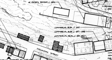
This map is an excerpt from an Historic Base Map: 1815-1865, which appears in the Cultural Landscape Report: Lower Town, Harpers Ferry National Historical Park, edited by Cathy Gilbert, Maureen D. Joseph, and Perry C. Wheelock. National Park Service, U.S. Department of the Interior, Washington, D.C., 1993. The Church's decision or ambivalence about constructing a parsonage on this parcel may be explained by the discouraging fact that Shenandoah Street and all of Lower Town, Harpers Ferry were subjected to frequent flooding.
Return to History of St. Peter's Church
© 2003 Copyright and All Rights Reserved
by Christopher Fennell
Last Modified: December 14, 2007 |