Map of St. Peter's Catholic Church, Rectory,
School House, Bell Tower and Privy, ca. 1865-1900

The map below shows the 1896 footprint of the Church in solid outline, and the 1833 footprint of the first Church building in dashed outline. The Rectory building, which served as the first school house from 1857 to 1886, is shown in solid outline to the left of the Church.
A second school house, which was built in 1886 and operated until 1899, is shown in the lower left of this map. This second school house was located on the north side of Shenandoah Street.
A timber frame bell tower stood just north of the Rectory from approximately 1880 until a year or two after completion of the 1896 Church renovations, which added a new stone bell tower on the southeast corner of the Church. The privy to the left of the Rectory was likely built in the 1850's.
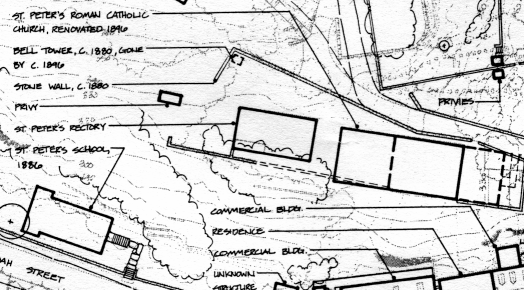
This map is an excerpt from an Historic Base Map: 1865-1900, which appears in the Cultural Landscape Report: Lower Town, Harpers Ferry National Historical Park, edited by Cathy Gilbert, Maureen D. Joseph, and Perry C. Wheelock. National Park Service, U.S. Department of the Interior, Washington, D.C., 1993.
Return to History of St. Peter's Church
© 2003 Copyright and All Rights Reserved
by Christopher Fennell
Last Modified: December 14, 2007 |